Use of vsTASKER to simulate high frequency radio waves propagation on a mountainous terrain.
The purpose of this simulation is to qualify telecommunications based on portable low powered (5-50 watts) radio equipment.
Radio devices characteristics are used for transmission and reception capacities while radio waves physics are computed for propagation, attenuation, topographic obstructions (…) according to the emitting power, selected frequency and atmospherics settings.
With the received signal strength (RSS), we are able to evaluate the quality of the reception (SNR) and the effectiveness of the radio equipment for a specific configuration of use, either in urban area, semi-urban, open field, wide hilly terrain, coastal situation, etc.
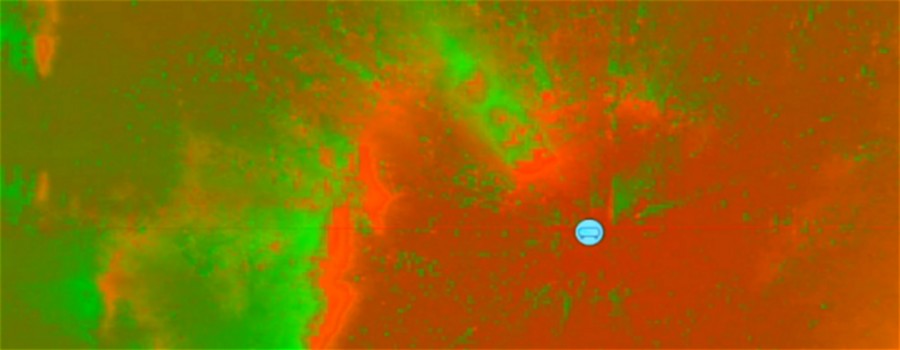
This prediction models combines the attenuation of the signal in free space with the attenuation sum based on ray-tracing mechanisms, to include the terrain and features obstruction and diffraction effects between the emitter and the receiver. Doing so, the terrain can change in real-time with immediate result on the signal strength. The terrain illumination shown in this demo is for validation of the prediction model. During a simulation run, only point to point link assessments are necessary.
With the received signal strength (RSS), we are able to evaluate the quality of the reception (SNR) and the effectiveness of the radio equipment for a specific configuration of use, either in urban area, semi-urban, open field, wide hilly terrain, coastal situation, etc.
This prediction models combines the attenuation of the signal in free space with the attenuation sum based on ray-tracing mechanisms, to include the terrain and features obstruction and diffraction effects between the emitter and the receiver. Doing so, the terrain can change in real-time with immediate result on the signal strength. The terrain illumination shown in this demo is for validation of the prediction model. During a simulation run, only point to point link assessments are necessary.
Terrain illumination is not a real-time process. In this demo, the terrain is 1600 square kilometers and the accuracy is 100 meters. 16 millions of queries to the radio propagation prediction model are requested to produce a single image. The actual model is a point to point link prediction whose computation time depends greatly on the terrain profile between the two points (and the efficiency of the terrain server to respond to numerous ray-tracing calls).
Features:
Features:
- Radio wave propagation physics
- Real-time point-to-point signal attenation prediction
- Radio network simulation
- Elevation data DTED
- Polygonal terrain (OSG, OpenFlt)
- Satellite communications
- Non real-time heatmap generation mechanism